Tag: maps

Displacement maps in Photoshop

Photoshop is a great tool not only for photographers but also for graphic designers. Some of the available features are definitely thought for photography while some others are almost exclusively oriented to graphic design. There are, however, some tools that can be used for both purposes and displacement maps is definitely one of those.

So what are displacement maps? I have to say that, at least to me, the name is far from self-explanatory. Displacement maps are a way to combine two images in a way that one merges into the other in a natural-looking way. The difference with simple merging is that there will be a primary and a secondary image, and the secondary one will be modified in Photoshop Textures and/or point of view so that it is somehow ‘immersed’ in the primary one.

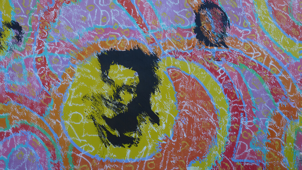
That sounds a bit confusing, I know. So let’s work with an example to make things clearer. Consider the following two images.

dispmaps02

dispmaps03

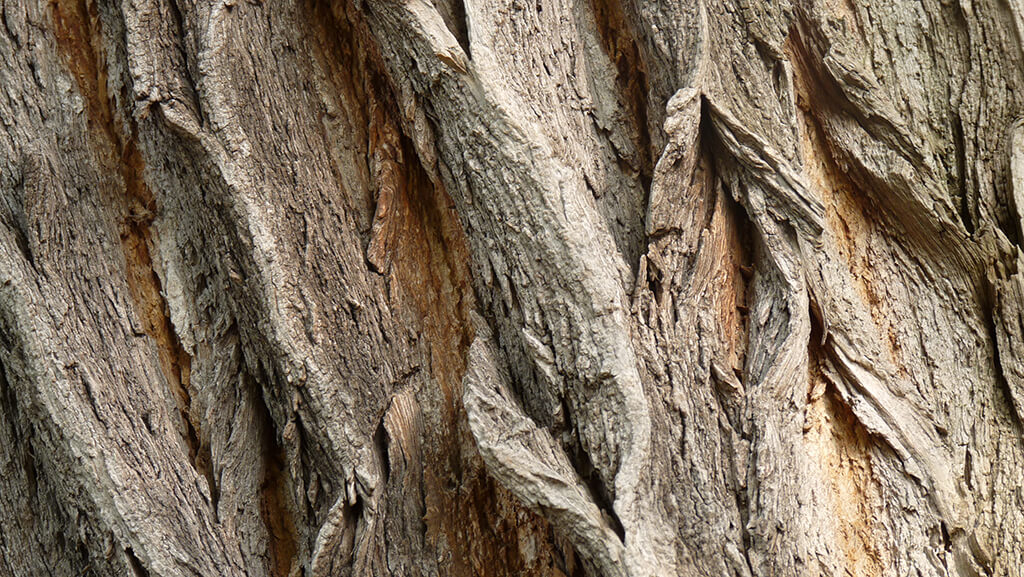
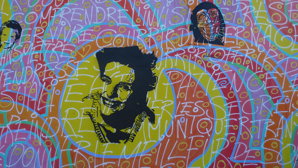
The first one is a texture of a tree and the second one a section of the Berlin Wall. So let’s say we want to make the painting look like if it was painted on the tree. There are two things that would change in the image if that was the case. The first one is that one would expect some level of transparency so that the structure of the tree would be visible. This can be achieved by playing with the available blending modes in Photoshop.

The second would be that the shapes withing the painting would be distorted due to the 3-dimensional nature of the tree surface. This is where displacement maps come into play.

In order to work with displacement maps you basically need three components: the two images that you want to combine and the displacement map itself. We have already seen the two images, so let’s take a look at the displacement map.

A displacement map is simply a high-contrast version of the image that will provide the texture. In other words, it is a high-contrast version of the bottom image, the tree in our case. What you have to do is basically open the image, convert it to black and white and increase the contrast a fair amount.

The reason for converting the image to black and white is that we want to work with the lighting contrast, not the color contrast. There are different ways to convert an image but since we are simply interested in getting rid of the colors without using any digital filter, simply going to ‘Image -> Adjustments -> Hue/Saturation…’ and reducing the saturation to a minimum will do the trick. As usual, before making any change either save your original image with a different name or duplicate your base layer (right-click on the name of the layer, usually ‘Background’ and click on ‘Duplicate Layer…’). This way you will avoid the mistake of replacing your original file and loosing it for good.

Now go to ‘Image -> Adjustments -> Brightness/Contrast…’ and increase the contrast until you are happy with the result. This is a subjective step, but in general I would say that you should increase the contrast until you start seeing some parts of the image to get clearly overexposed. For the image of the tree here, I increased it to 100. Bear in mind that for some images you might have to increase the contrast even further. If that is the case, simply repeat the process as many times as necessary.

dispmaps04

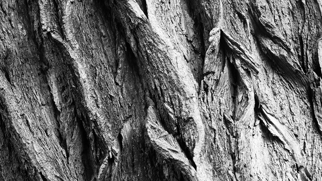
And that’s it. This will be our displacement map. The next step is to save the file with any name we want with a .PSD extension. Next, we go to our original image of the Berlin Wall and apply the displacement map to it. For this, go to ‘Filter -> Distort -> Displace…’ and a dialog like the one in the following image will appear.

dispmaps05

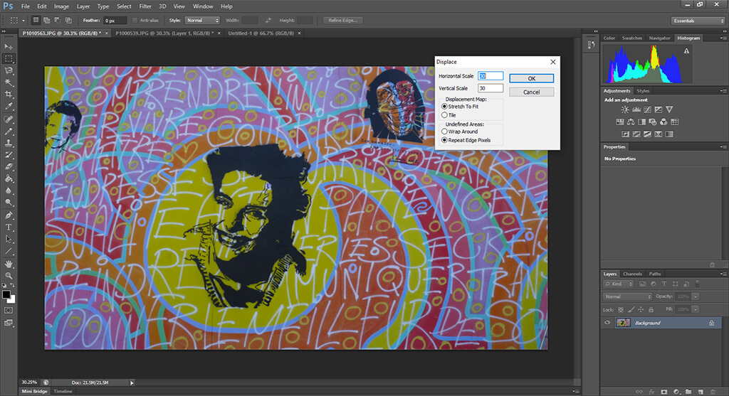
The scales are a factor by which the image will be distorted to match the displacement map and you usually want to keep them to relatively low values. You can of course experiment with these values and see the results you get. The next two options correspond to how the displacement will actually work and they are important when the image and the displacement maps are not the same size. In general, it is best to match the sizes before distorting the image, since the result is much smoother.

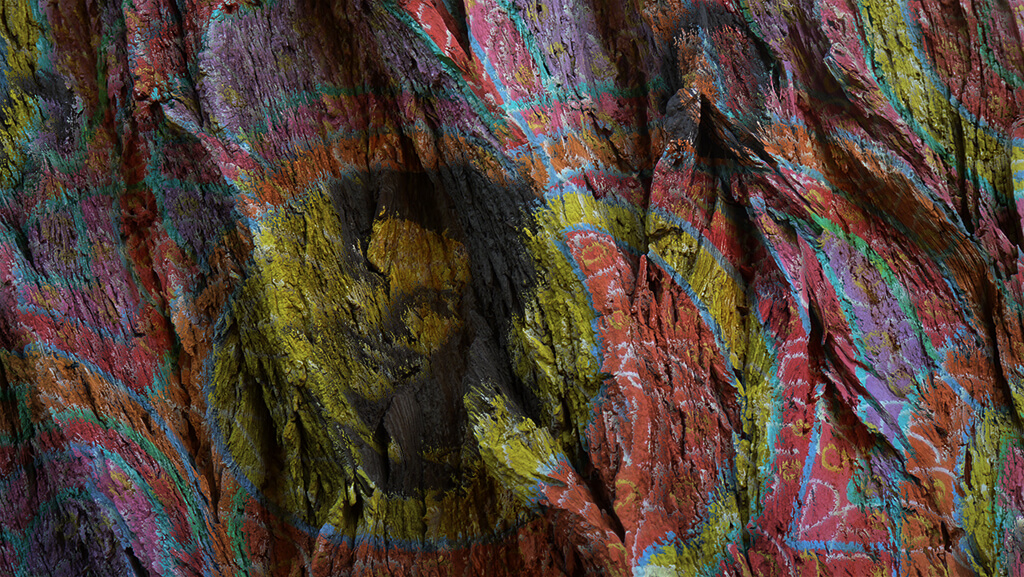
After you click ‘OK’, a dialog will appear asking you to select the file containing the displacement map. This is the one we already created before. After applying it, your image will look strange, like the one below.

dispmaps06

While it might be a bit hard to see, the image already has the tree patterns somehow embedded. Now you have to select the whole image (Ctrl+A in Windows, Cmd+A in Mac), copy it (Ctrl+C in Windows or Cmd+C in Mac) and paste it (Ctrl+V in Windows and Cmd+V in Mac) on the original tree image in order to create a new layer on top of it.

Next, change the blending mode to ‘Multiply’ and you have your blended images that makes it look like if the painting was indeed created over the tree! You can adjust the opacity of the top layer as well as the contrast and saturation in order to get the result you want, but in general, as you can see, the whole process consists of just a couple of steps and the result is amazing.

dispmaps07

Now go ahead and re-visit your images to find where you could apply this and give it a try. And, as usual, don’t hesitate to post any question in the comments.

How to master the content aware and patch tool in photoshop?

Finding the Right Spot – Planning Before Your Trip

For people who enjoy travel photography, one of the most difficult challenges is to find original compositions that help you show the city you want to show in a special way that leaves your signature on the final image, so to speak. With millions of people (literally) visiting a touristic city each year (for instance, more than 32 million people visited Paris in 2013!), probably all the famous landmarks have already been photographed from every possible angle so the only choice you have to produce a special travel image is to include changing subjects like local people that add something to the scene or if you are lucky enough to be there while some dynamic component is happening, like a specially beautiful sunrise/sunset or some special event.

That said, most of us will anyway try to come back from our trip with our own versions of emblematic landmarks like the Eiffel Tower in Paris, the Tower Bridge in London, or the Empire State in New York, to name just a few.

_MG_0518 copy_newvf_nob

While many of these photos will lack originality, I still enjoy taking them for different reasons. On the one hand, I just like having them in my portfolio; there is a reason for those points of view being so famous after all! On the other hand, taking your own version of famous shots is a great way of practicing and judging yourself since you have many other pictures to compare yours to and you can easily find things that you prefer in those of others, giving you a hint on what you need to improve in your own workflow.

Now, while the job of deciding which spot we want to capture our photo from has partially been made by others, it is quite common that finding where a specific photo has been captured from is not as easy. Today I want to share some tips about finding the right spot in order to prepare for your trips so that you can make sure you don’t miss any of the photos you want to make.

Planning for time

The first thing you have to decide is when you want to make your photo. The best times of the day to take photos with natural light are the golden hour (right after sunrise) and the blue hour (right before sunset). This is particularly true for cityscapes and, even though this does not mean that you should not take your camera out during the rest of the day, given the short duration of these particular times, you will end up with the possibility of capturing only two good pictures per day (and that if the weather plays along, which is not often the case). For this reason, it is important to plan ahead and know where you are going even before starting the trip.

_MG_4953_newv_1024_nob

Now, even during the golden and the blue hour, the angle from which the light is coming is important when planning for your photo. The effect that you can get from capturing your subject when the Sun is behind it is completely different than the one you can get when the Sun is illuminating it. For this reason, the time of the day you want to take your picture is closely related to the location you will take the picture from.

Planning for location

The first thing you have to do is, of course, choose the photo you want to take. Take, for instance, this photo of the Golden Gate Bridge in San Francisco, USA.

_MG_0137_1024_nob

The photo was taken before sunrise to sunrise using an ND filter to capture the motion of the water and the clouds. Now, if you were planning to take your own version of this same image and no information regarding the time of day and location were given to you, there are a couple of things you would need to consider.

First, wherever this was taken from, the Sun was illuminating the bridge directly, which means it was located behind the photographer. This by itself does not give us information on the time of day (morning or afternoon) so we need to find out where the photo was taken from. For this, any map service will help (I personally use Google Maps). So the first thing you need to do is search for your subject. This is a screen capture of the Golden Gate Bridge in Google Maps.

goldengate1

From the perspective (unless the photo was mirrored which is unlikely), there are only two locations where the photo could have been taken from: the wide region denoted as Bake Beach at the southwest of the bridge or close to Fort Baker at the northeast. The best way to discern between both spots is looking at the ‘Earth’ view. This presents satellite images that help distinguish characteristic features. The next two images show satellite photos of the Baker Beach and the Fort Baker areas respectively.

goldengate2

goldengate3

If you look carefully to both images, you can see that all the area surrounding Fort Baker is mostly covered in concrete, whereas the area surrounding Baker Beach is, well, a beach. This latter matches what can be seen on the original picture we want to reproduce, giving an unambiguous hint on the location where the photo was taken from.

Once the location has been determined, knowing that the Sun rises at the East and sets at the West, it is easy to determine as well that the photo was taken before sunset since, as we said before, the Sun was located behind the photographer.

Some spots might be a bit more difficult to establish. It might be necessary, for instance, to look closer at the satellite images to find specific features such as rocks on the water or crossing streets. The workflow, however, is always the same. So don’t forget to plan ahead so you can make the most out of your trip!